One of Adrian’s Postdoctoral research projects, led by Professor Humphrey Southall at the University of Portsmouth, assisted by Dr Paula Aucott, examined contested geographical naming.
The research used multiple modes, including:
Monitoring interactions on Twitter and Facebook Online Social Networks (OSNs) sampled and collected over time.
Web-scraping of websites ‘in-country’ and ‘out-of-country’ using NordVPN and custom-built Python scripts.
Physical examination of corpora held in copyright libraries around the world.
While Humphrey and Paula got to travel, Adrian collected several hundred thousand OSN records using George Washington University’s excellent Social Feed Manager and wrote code in Python and Bash to programmatically control NordVPN from an Ubuntu virtual machine using openpyn.
Lists of websites, or specific URLs, could then be captured virtually from over 100 countries. Pages were scraped using selenium with text and images saved to a PostgreSQL database. Non-English text was translated using Google’s Translate API.
This research project was conducted confidentially so no publications have been produced. However, together with the physical visits, a trawl of online material produced several interesting results.
Geographical data have always been ‘big’, presenting special challenges for geo-computation. Adding Web-scale ‘Big Data’ makes things even bigger, into the Gigabytes, Petabytes, Terabytes or more…
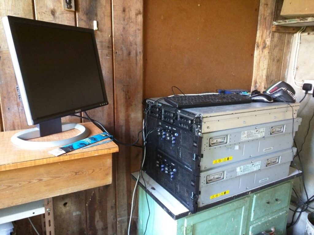
Speed of processing – even on Adrian’s specially commissioned ‘shedputer’, two 4U IBM System X3850 M2 computers with 24 processor cores, 128GB RAM each and RAID10 solid state disks, pictured in situ, along with a 2U Dell PowerEdge 2950 – was also an issue.
Working with Professor Richard Healey, Gary Burton and David Marshall at the University or Portsmouth, Adrian investigated and assessed the use of High Performance Computers (HPCs) in the Institute of Cosmology and Gravitation’sSCIAMA Supercomputer for Big Data workloads.
Running MapR’s flavour of Hadoop on a 5-node HPC cluster with 48 processor cores, 100GB memory and 6TB disk space and Oracle’s 12c Relational Database Management System (RDBMS) on a 2-node HPC cluster brought significant performance gains for data ingestion, query and analysis.
The old instructions for interfacing MapR (now defunct) with Tableau through Java Database Connectivity (JDBC) connectors is reproduced below, in case it is of any further use to the community.
The supercomputing tests also led to further work with Oracle, including one of the first ‘field tests’ of the Oracle Cloud, including usage of a highly-specified Exadata machine that performed very well with the Oracle 12c RDBMS.
Technology marches on and computing power continues to increase. Adrian’s shedputers still exist but most heavy lifting today is now done in the Cloud…
Adrian embarked upon Doctoral research in the Department of Geography (as was) at the University of Portsmouth, part-time, in 2011 under the supervision of Professor Richard Healey, who had taught him years earlier as a lecturer on the MSc GIS programme at the University of Edinburgh.
Adrian’s PhD was finally awarded, years later, in 2018. By then the Department of Geography had been renamed the School of the Environment, Geography and Geosciences. That name has since been changed again to the School of the Environment and Life Sciences. And, in the interim, Adrian had decided that his research had much more to do with Computational Social Science than Geography!
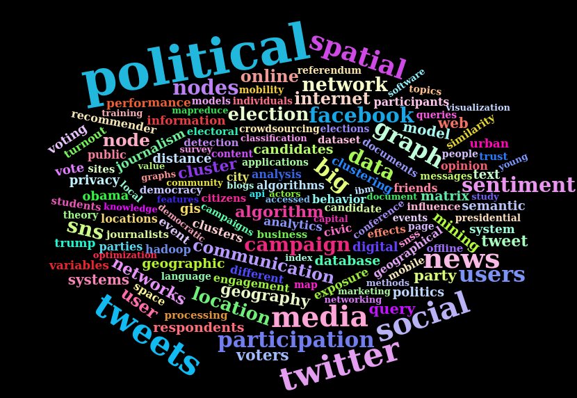
Only recently has it become possible, as ‘Web 2.0 desires to read, write, and share personal information’ have developed (Jung, 2015, p53), to know what large numbers of people are saying or thinking as they comment on, share and interact with content online. The rapid growth of Online Social Networks (OSNs) such as Facebook and Twitter has brought billions of users and countless user messages into the public domain. User Generated Content (UGC) now abounds and the traditional communications model of Habermas’ (2011) Public Sphere incorporating governmental, judicial and media power-players appears to have moved towards a more pluralistic model involving overlap between public and newly digitally-enabled ‘private’ spheres (Papacharissi, 2010).
Political opinions expressed online are now widely-made, shared, and increasingly accessible for download from OSN platforms; some records are coordinate-geotagged and many more make frequent toponymic mention of place (Han, Cook, & Baldwin, 2014). For privacy reasons, other than to site operators, IP addresses are not made available in OSN data downloads; removing one of the easiest – although not necessarily accurate (Backstrom, Sun, & Marlow, 2010) – methods to geographically estimate the location of social media communications. If, as Surowiecki (2004) has suggested, the ‘Wisdom of the Crowds’ really can provide more accurate prediction, is it possible that ‘mining’ massive amounts of OSN data for spatiotemporally expressed political opinion could help to detect events, or possibly even ‘call’ an election? After all, as some scholars have suggested, ‘there is a strong relationship between political information [consumption, news seeking] and political participation; the more we know about politics, the more, and more effectively, we participate in political activities’ (Feezell, 2016, p495).
The research was based around:
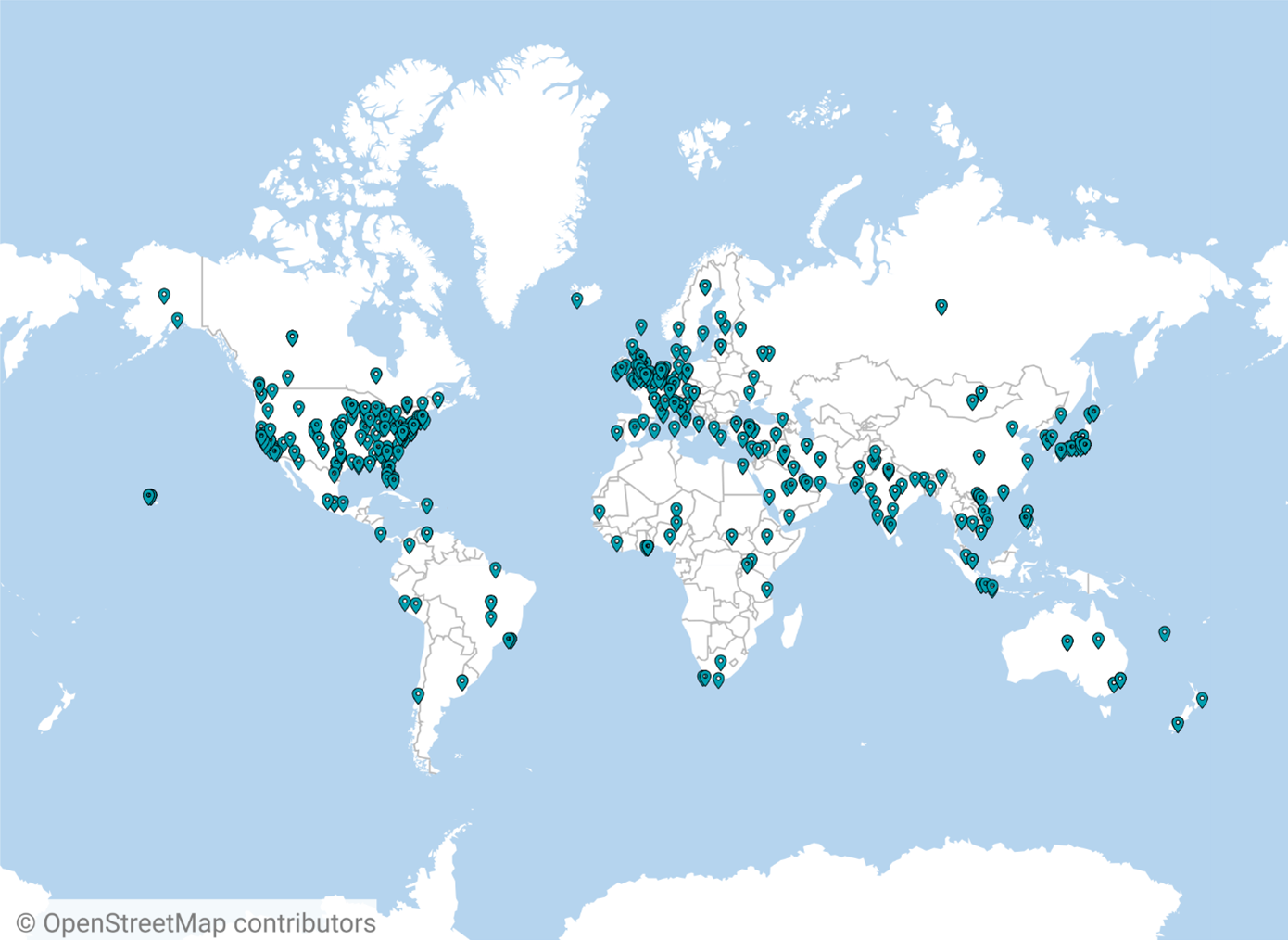
The opinions, expressed in the public domain, of ~2.4 million users of Online Social Network (OSN) platforms, predominantly of the popular micro-blogging site Twitter, but also of Facebook, have provided the raw material examined in this research. In 1997, 2000 and 2001 Internet users consumed political information from publishers’ websites; today they consume, link to, share and comment on publishers’ material as well as creating original content of their own. The ~8 million records of social media message text, metadata and linked/shared content accessed during the 2012 US Presidential Election and the 2014 Scottish Independence Referendum campaigns have provided an excellent, if at times hard to interpret, politically discursive corpus that has been text and data-mined in various ways.
It proved impossible, unfortunately, to impute localised voting intention from Twitter tweets or Facebook posts but the research did reveal important differences in the communications preferences of different types of users of the two Online Social Networks (OSNs):
Coordinate-geotagging users make fewer toponymic mentions in message text than non-coordinate-geotagging users of two popular OSN platforms;
Coordinate-geotagging users make far fewer URL link shares than non-coordinate-geotagging users, and;
The content of URLs shared by coordinate-geotagging users makes fewer mentions of place than content shared by non-coordinate-geotagging users.
There’s no real substitute for reading the thesis, but at 120,171 words (69,014 excluding references and appendices), it is quite a heavy read.
For a condensed summary, based on a presentation of the research at the PLATIAL ’19 conference, held at the University of Warwick on 5th September 2019, please flick through the presentation below.
The original slides, in Microsoft PowerPoint format, may also be downloaded.
The completion of his PhD, something Adrian had returned to later in life, after an 18 year career outside academia in business, has been a notable achievement.
For anyone else considering Doctoral research the challenge is recommended. It is probable, however, that starting younger and working on things full time makes for a somewhat easier approach…
Contribution delivered in the School of the Environment, Geography and Geosciences (SEGG, now SELS) at the University of Portsmouth in the 2015-2016 academic year.
Contribution delivered in the School of the Environment, Geography and Geosciences (SEGG, now SELS) at the University of Portsmouth in the 2015-2016 academic year.
Modelling, Analysis and the Web was open to L5 (2nd year) students of Geography, Adrian’s contribution covered one two-hour teaching and demonstration slot using slides previously prepared for the Business Geographics course in the School of GeoSciences at the University of Edinburgh.
Together with demonstration the material illustrated some of the potential for downloading, or otherwise harvesting, [geo]data from the web, whether from new government ‘open data’ silos or from nascent depositories such as Twitter’s tweet stream.
Colleagues at academic institutions interested in the original PowerPoint slides and bibliographic database may make contact to request access.
Businesses, government departments, third sector organisations etc. may wish to explore consultancy options.
Contribution delivered in the School of the Environment, Geography and Geosciences (SEGG, now SELS) at the University of Portsmouth in the 2015-2016 academic year.
GIS and Database Management Systems was open to L5 (2nd year) students of Geography, Adrian’s contribution covered one two-hour teaching and demonstration slot.
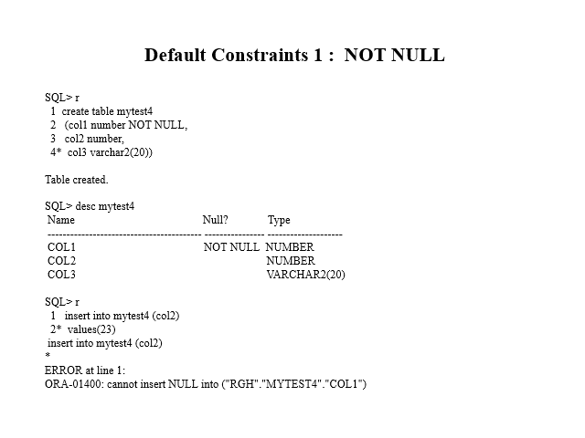
A step back in time, involving scanning and converting a Professor’s ancient acetates into PowerPoint to explain and, more importantly, demonstrate the concept of Relational Database Management Systems (RDBMS) and Structured Query Language (SQL) in GIS.
The Oracle 8 (?) user manual had never looked so good and the lecture was better received than this slice of history would suggest…
Colleagues at academic institutions interested in the original PowerPoint slides and bibliographic database may make contact to request access.
Businesses, government departments, third sector organisations etc. may wish to explore consultancy options.
Contribution delivered in the School of the Environment, Geography and Geosciences (SEGG, now SELS) at the University of Portsmouth in the 2016-2017 academic year.
Applied GIS was open to L4 (1st year) students of Geography, Adrian’s contribution covered one two-hour teaching and demonstration session introducing students to recent developments in Big Data processing and the [geo]visualisation of Web scale datasets.
Some of the websites mentioned in the slides have now been brought back from archive on this site, as they still provide some excellent examples of GIS used in anger on the web.
Colleagues at academic institutions interested in the original PowerPoint slides may make contact to request access.
Businesses, government departments, third sector organisations etc. may wish to explore consultancy options.
Designed and delivered in the School of the Environment, Geography and Geosciences (SEGG, now SELS) at the University of Portsmouth in the 2019-2020 academic year.
Geographies of Health and Urban Wellbeing was open to L5 (2nd year) students of Geography. The course, which covered infectious diseases amongst many other topics, progressed as the 2020 Covid crisis unfolded. Luckily, the lectures were pretty well complete before the first lockdown occured!
The course consisted of a series of ten lectures in two-hour slots with five two-hour lab-based practical sessions featuring content substantially revised from the original slides and practical exercises developed by Professor Liz Twigg, who had retired.
This marked one of three occasions in which Adrian replaced a professor while teaching at Portsmouth.
The Unit Handbook for Geographies of Health and Urban Wellbeing, including selected references etc., is shown below.
Contribution delivered in the School of the Environment, Geography and Geosciences (SEGG, now SELS) at the University of Portsmouth in the 2019-2020 academic year.
Image Processing and Spatial Data Analysis was open to L7 (postgraduate) students of Portsmouth’s MSc GIS degree. Adrian’s contribution covered three three-hour teaching and practical sessions introducing students to programming concepts and the Python programming language.
The Unit Handbook for Image Processing and Spatial Data Analysis, including selected references etc., is shown below.
Designed and delivered in the School of the Environment, Geography and Geosciences (SEGG, now SELS) at the University of Portsmouth in the 2019-2020 academic year.
GIS and Remote Sensing was open to L5 (2nd year) students of Geography. Adrian was Joint Course Leader, covering the GIS side of things while his colleague, Dr Howard Lovell, covered Remote Sensing.
Adrian’s work consisted of a series of five three-hour slots featuring a lecture followed by a lab-based practical session based around a series of mapping and spatial analysis operations he developed to run in ArcGIS Pro, based on his own experience of taking an onshore renewable wind energy generating scheme through planning at Ascog Farm, the family farm on the Isle of Bute, Scotland.
To get a taste of what was involved, the instructions for the second practical session, by which time things had started to get a bit more exciting, are reproduced below.